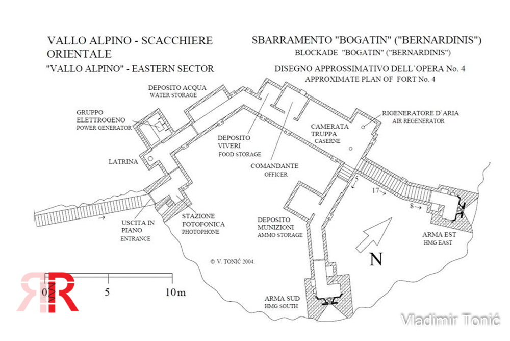
Italijanska podzemna utrdba iz obdobja rapalske meje, del sistema Alpski zid. Video: https://w.wiki/FZh2
Bogatinsko sedlo - Center odpora 4
🇸🇮 Slovenia
Forts
Gallery
Description
Edit Location
Sign in to edit this location.
Location on Map
Discussion
No comments yet. Be the first!
Nearby Locations
Other mapped sites in the surrounding area.
Bogatinsko sedlo - center odpora 4Slovenia
0 kmID 7779503016View
Bogatinsko sedlo - center odpora 3Slovenia
0 kmID 0009477820View
Bogatinsko sedlo - Center odpora 3Slovenia
0 kmID 2407831626View
Bogatinsko sedlo - center odpora 2Slovenia
0 kmID 1719647363View
Bogatinsko sedlo - Center odpora 2Slovenia
0 kmID 6323822108View
UnnamedSlovenia
1 kmID 6893428633View
Bogatinsko sedlo - Center odpora 1Slovenia
1 kmID 1519055404View
UnnamedSlovenia
1 kmID 2156336601View
Trenches 838943380Slovenia
4 kmID 1547032252View
Utrdba Alpskega zidu iz leta 1939 na PologuSlovenia
4 kmID 9633344944View
Utrdba Alpskega zidu iz leta 1939 na PologuSlovenia
4 kmID 3606595931View
Trenches 1209119515Slovenia
5 kmID 4268630082View
Keywords
Bogatinsko sedlo - Center odpora 4FortsPublic AccessBunkerAtlashistorical bunkermilitary heritage