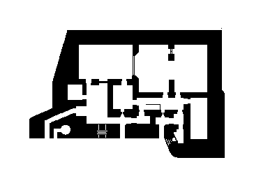
L479 is a World War II German-built bunker located on the northern coast of France. Part of the extensive Atlantic Wall fortifications constructed by Nazi Germany, this concrete structure was originally designed as part of the coastal defense system to protect against Allied invasion. The bunker represents the military engineering and strategic planning of the Third Reich during the occupation of France, when thousands of similar fortifications were built along the French coastline.
L479
🇫🇷 France·Added by @bunkeratlas
Unknown
Military Bunker
Gallery
Description
This research is automated and may contain errors.
Edit Location
Sign in to edit this location.
Location on Map
Discussion
No comments yet. Be the first!
Nearby Locations
Other mapped sites in the surrounding area.
UnnamedFrance
0 kmID 6059376971View
L413AFrance
0 kmID 9011190207View
Splitterschutz FuMG FreyaFrance
0 kmID 3846887201View
UnnamedFrance
0 kmID 6486664253View
Fundament BarackeFrance
0 kmID 7618213775View
Bauform 58c "Tobruk"France
0 kmID 8392728879View
L409AFrance
0 kmID 3312670974View
Bauform 58c "Tobruk"France
0 kmID 3255472462View
Bunker near La RochelleFrance
0 kmID 9375725999View
FA GebäudeFrance
0 kmID 0338594907View
FA TrafoFrance
0 kmID 9678229362View
675France
0 kmID 7327710703View
Keywords
L479OtherUnknownMilitary BunkerBunkerAtlashistorical bunkermilitary heritage